BLACK MOUNTAIN
And other Mysterious Sites of the 15°S Parallel
Copyright © Paul V Young 2015
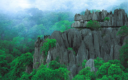
Fear of the unknown often causes us to attribute a sinister nature to structures, formations and occurrences that are beyond our present level of understanding. In the case of Black Mountain, just outside Cooktown, Queensland, its direful notoriety is magnified by its very appearance and configuration, not to mention its fearsome reputation for ‘taking’ many hapless individuals who have dared to venture onto it. Known to Australian Aboriginals (who generally keep a respectful distance from it) as ‘Kalkajaka,’ the mountain is actually a huge mass of black boulders, and underneath it is an extensive maze of caves with corridors and chambers. Sitting on the 15°S Parallel of Latitude, at 145°E Longitude, Black Mountain has a grim history of eerie encounters and unexplained disappearances.
Scattered around the globe are many locations, both man-made and natural, dubbed sacred sites or hallowed grounds. They are considered to be places where an invisible realm overlaps the physical 3-D world. Some of these exude an uplifting sense of spirituality and may be aptly described by the Celtic term, ‘Thin Places.’ Black Mountain, while not presenting such a peaceful atmosphere, does fit the pattern of being an energy vortex, portal or entrance to an underworld. Over the past century and a half, there have been numerous stories of those who have ventured into the area never to return, often with searchers going in to look for them, who have also vanished. Old local legends speak of demons, monsters and huge reptiles, while modern day alternative researchers claim it is artificially built and sits atop an underground empire populated by an extra- or ultra-terrestrial race, and an interdimensional gateway and time portal.
The 15°S Parallel draws a line around the upper portion of the southern hemisphere that reveals a number of intriguing sites along its path. While the rows of latitude are man-made contrivances, not earth-grids or ley-lines, there is growing speculation that they have a guiding purpose and proportion behind them. A number of northern hemisphere parallels have been attracting growing attention: The 37°N being called the Paranormal Highway[i]; The 33°N known as the Masonic Line[ii]; The Pyramid Line at 30°N[iii]; The 25°N crossing the Bermuda Triangle & Zone of Silence[iv]; The Time Rivers Line at 19.5°N [v]. While latitude was originally conceived by the ancient Greeks, the Roman scholar Ptolemy was the first to place a grid system on a planetary map in the second century CE (he knew the world was round). This work was lost, then rediscovered and put to valuable use in the fifteenth century. Black Mountain, along with other sites we will look at, sits on that line formed between an angle 15 degrees south the equator and the centre of the world. Is it simply a Pythagorean principle, or cosmic geometry? Right around the globe there are energetic sites, laid out in straight lines, often at great distance apart, that appear to form links in a chain.
These locations raise several points for us to consider:
As we follow the 15°S Parallel horizontally around the globe, we pass through mysterious and mystical sites in Peru, Bolivia and Brazil in South America, then Angola, Zambia and Madagascar in Africa. We start out from north Queensland, Australia.
What’s beneath Black Mountain?
The Black Trevethan Range is actually a stack of black granite rocks, over three hundred metres high and stretching more than three kilometres long. Some of the larger individual boulders are over six metres in length. Given their black colour by a coating of iron and manganese oxide, the rocks ring with an odd metallic sound when struck, while noises described variously as anything from wailing to music emanate from within the mountain. These could be caused by wind or the contraction of the boulders, but some claim that the mountain is hollow. The limited exploration through entrances into the formation itself, by the very few who have ventured in and returned, reveals a maze of caves, tunnels and chambers below Black Mountain, and those who have survived it found the experience so chilling that they never want to return. Indeed, some have been unable to speak of it at all.
The list of disappearances is legendary, but what is most astonishing is that many of them involve not one lone wanderer, but several people at a time, some on horseback. The first documented case after white settlement in the region was that of a farmer called Grayner in 1877 who, while rounding up stray bullocks, vanished into Black Mountain complete with his horse and a calf. During the ensuing two decades there were two instances of outlaws taking refuge in the mountain and never returning. The first was an escapee known as Sugarfoot Jack who fled there with two of his henchmen, never to be seen again. The second was when a Constable Ryan from Cooktown chased a wanted man to the foot of the mountain. Both disappeared and trackers then followed their trail to the mouth of a cave, finding no further trace of them inside. In yet another later multiple disappearance, a station owner called Harry Owens went missing while looking for stray cattle around Black Mountain. His partner George Hawkins, after alerting police, went out searching for him and also vanished. Two native police trackers went looking for them both but, after following the trail into a cave entrance, only one came back out and he was too shaken to give a clear version of what had taken place. Other accounts of individuals who have gone missing there can be found in Brisbane’s Public Library or on various websites[vi].
European bloggers Ivan and Danny Mackerle claim to have been part of an amateur group who did some tentative exploration inside the caves of Black Mountain in 2009, although their narrative blends myth and hearsay in with their own first-hand experience[vii]. Danny neatly summarises the speculations of ‘mystery buffs’ on his website:
“Kalkajaka is a mountain unlike any other. That's why mystery aficionados claim it was built by artificial means, and that it is a ruin of an ancient extinct civilization dating back to the dawn of the world. Its recesses are thought to harbour wondrous mysteries; chronicles of sublime priestly wisdom, remains of ancestral kings, and best of all, untold treasures. The way into the heart of the mountain has been guarded by the spirits of the dead, demons, and poisonous snakes by the hundreds. Modern legend has it that this is but one gate to an underground empire, populated by an extra-terrestrial race of ‘reptilians’ and a dero-like group of human slaves, kept under reptilian control with the help of implantation, technosis, and the like.”
In the end, however, they found the formidable aura of Black Mountain simply too daunting and wound up their investigations without any real resolution to the enigma:
“We tried our luck in different spots and soon realized that an intricate underground web of passages and pathways was underpinning the entire surface of the mountain. Thus we were able to descend further down and explore many narrow stray paths, but in the end Black Mountain was able to preserve its mystery. We never did find a way into its legendary heart.”
Traversing the Sites of the 15°S Parallel
NAZCA
Following the15°S Parallel of Latitude eastwards, we cross the South Pacific, passing over Vanuatu and Samoa and onwards to Nazca, Peru, at coordinates 15°S, 75°W. The Nazca Culture flourished here from the 1st century BCE to the 9th century CE and, as indicated by ancient tunnels and caves in the region, they industriously extracted gold, silver, copper, zinc and iron from the ground. If you were looking for a diversity of mineral wealth, you couldn’t choose a better location on the planet than the nitrate-rich environment of Nazca. Unfortunately, anthropologists who are trying to examine what remains of pre-Incan activities are severely hampered by ruthless modern-day miners[viii]. In fact many people who were residing in modern Nazca have been displaced. According to Wikipedia, “Since 1997, Nazca has been the location of a major Canadian gold mining operation. The people who were living on the land for the last 2000 years did not have a property title to the land, so they were displaced without legal problems. Since then, there have been attempts to legalize poor citizens' ownership of their land and their fixed property, in response to Hernando de Soto's research on the poor”[ix] There is even evidence that the over-zealous mining company has damaged one of the world’s most awe-inspiring UNESCO listed Heritage Sites – the Nazca Lines[x].
The Nazca Lines are enigmatic in a number of ways, not least that they cannot be discerned from ground level, but only really appreciated from the air. These ‘geoglyphs’ mostly depict animals and plants, but some are geometrical shapes up to ten kilometres long and may be mathematical symbols. Interpretations of the figures vary, but it is accepted that they are of astronomical and spiritual significance. It is difficult to read the reports and discussions of various archaeologists, historians, alternative researchers and New-Age mystics, without the speculation of ETs or Inter-dimensional beings arising. When considering the magnetic allure of Nazca’s layout, with its lines seemingly geomagnetic or perhaps even electromagnetic in nature, many compare it to the more recent phenomenon of Crop Circles, along with much older monuments and glyphs around the world, inasmuch as they could be inter-dimensional messages we have yet to interpret. Its lines and arrows seem to point to the Lake Titicaca Basin, and we will see Nazca mentioned again when we investigate Mato Grosso in Brazil. Is there a subterranean tunnel connecting sites along the 15th Parallel?
LAKE TITICACA BASIN
The 15°S Parallel intersects with the 69°W Meridian at the northern end of the basin of Lake Titicaca in Bolivia. From 300 BCE to the 9th century, it was home to the Tiwanaku culture, whose ability to quarry and transport gigantic blocks of stone was staggering. A few centuries after the Tiwanaku people disappeared, the Incas arrived on the scene and are believed by Andeans to have actually emerged from the lake, led by Viracocha. There are many islands in Titicaca and those named The Sun and The Moon are sacred places. With the recently designated phenomenon of ‘UWAs’ (Unidentified Underwater Anomalies) there are a number of websites and You Tube videos offering evidence of underwater buildings and roadways submerged in the lake, picked up by Google Earth[xi]. One needs only to Google ‘Lake Titicaca UFO’ to see how many enthusiasts are certain there is a UFO base or Mother-ship on the lake bed, and how locals and visitors alike claim to have witnessed UFOs entering and departing the lake surface. Just a little inland from the lake is Puerta De Hayu Marka, the ‘Gateway of the Gods’. Carved into a natural rock face and measuring 7 x 7 metres, it looks like a gigantic door with a smaller alcove in the centre at the base. There is a groove in the centre of the alcove into which, it is said, a golden ‘Sun disc’ was inserted to activate an inter-dimensional gateway. Amaru Meru, the first priest-king of the Incas, was alleged to have arrived via this portal. As with other sites we are looking at, there are entrances to caves and tunnels around the basin which, it is claimed, are part of a greater network running beneath Peru, Bolivia and Brazil.
CUIABA & MATO GROSSO, BRAZIL
Moving a little further east along the 15°S Parallel to the 56°W Meridian, we find ourselves in Brazil at the city of Cuiaba, in the centre of the Mato Grosso. If even a fraction of what is reported to have been experienced and recorded here is true, this is an astounding region begging to be explored and understood by the modern world. Stories abound, not only of lost cities which hoard treasures of silver and gold, but also of subterranean cities and ancient civilizations consisting of white-skinned, golden haired people who are the true first Brazilians, claimed by some to be descendants of a colony of Atlantis. There is said to be a network of tunnels connecting this underground world with Tiahuanaco, Nazca and other major sites on the continent. In fact, to quote from the writings of Dr Raymond Bernard: “It is claimed that the earth is honeycombed with a network of tunnels, which are especially abundant in South America; and that these tunnels lead to subterranean cities in immense cavities in the earth. Most famous of these tunnels is the `Roadway of the Incas' which is said to stretch for several hundreds of miles south of Lima, Peru via Cuzco, Tiahuanaco and the Three Peaks, going on to the Atacama Desert where all traces of it is lost. Another branch runs to Brazil, where it is connected by tunnels to the coast.”[xii]
Expeditions to these caves and tunnels have proven to be just as intimidating as the attempts to explore Black Mountain recounted earlier in this article. The entrances to them are said to be fiercely guarded by the Murcego, or ‘Bat’ Indians, a dark-skinned tribe who are short in stature but possess great physical strength. The Krupp expedition went searching for a ‘lost city’ in the Mato Grosso in the early 1900s with up-to-date equipment, armed men, Indian guides and sturdy pack animals. “However, the guides soon deserted the party, wild Indians began to attack them at every turn, and the explorers and their animals fell prey to the terrible jungle heat and appalling conditions. They, like their less well-prepared predecessors, ultimately had to turn tail and head back to civilization.”[xiii]
The most famous adventure in the Mato Grosso was that of Colonel Percy Fawcett who, after two decades charting jungles in Peru, Bolivia and Brazil, set out on his final expedition from Cuiabá on 20 April 1925 with his eldest son, Jack Fawcett, and Jack's long-time friend Raleigh Rimmell. They were accompanied by two Brazilian labourers, two horses, eight mules and some dogs, with all the necessities such as canned foods, powdered milk, guns, flares, a sextant, and a chronometer. Fawcett publicly stated he was searching for a lost city he called ‘Z,’ and only confided in a few friends about his obsession with locating a subterranean city that was said to be reached via a narrow tunnel. Enigmatically, he left instructions that no-one should search for them if they went missing. The entire group did indeed go missing without trace and, despite several rescue missions being mounted against his instructions, every clue pursued turned out to be a false lead. Colonel Fawcett had been intrigued for a long time about the legends of the ‘white Indians with blue eyes’ who still dwelt somewhere in Mato Grosso, perhaps underground. He was a friend of Arthur Conan Doyle and inspired the latter’s novel entitled The Lost World. While it is possible that they were attacked and captured by the Bat Indians, many commentators, including the Colonel’s wife Nina, remained convinced that the group were still alive over the ensuing decades. Did they find their underground city and stay there? Are there tunnels with subterranean vehicles that traverse the regions and continents? Is there a hidden world right below our feet? Let’s follow the 15°S Parallel further.
ANGOLA, AFRICA:
Continuing in an easterly direction around the globe, we cross the Atlantic Ocean until making landfall at the city of Namibe (formerly Mocamedes) in Angola, sitting on the 15°S Parallel at the 12°E Meridian. In the hinterland to its east along the 15th Parallel is the rounded granite hill known to the locals as ‘The Sacred Hill of Mucuisses’ and in its caves are a collection of prehistoric rock engravings and paintings, said to be the finest anywhere in the world. Known as the Tchitundu Hulu artworks, they depict animals, both real and mythical, plants and concentric circles thought to represent the sun and the stars. The images of people are not elongated figures like others in Africa, but broad-shouldered solid beings with round heads.
The inhabitants of Mucuisses and the southern Angola region 20,000 years ago were the San people, who share similar physical and language characteristics to the Khoikhoi, thus today’s descendants are known collectively as Khoisan, the first inhabitants of sub-Saharan Africa. The word Khoisan is a combination of the two names, but holds another connotation for them: ‘Men of Men’. You may have heard of them referred to as ‘bushmen’ - they are the tribes who use click consonants when they speak and their languages are not spoken much elsewhere across Africa. The Khoisan have short frames with long legs when compared with other African peoples, with copper brown skin and eye folds that are more similar to Asian peoples.
Present day Khoisan are claimed to be direct descendants of those who first settled here 20,000 years ago, but there is a gap in their history and it is not known where they disappeared to for a lengthy period. They are currently at risk of extinction, as only about 5000 of them still survive in southern Angola. Sara Tishkoff from the University of Pennsylvania undertook a genetic study in 2008 and concluded that one of the oldest African bases of humanity lies in the Khoisan region, in the coastal zone nearest to the Angola and Namibia border. According to her study, the Khoisan people have “the highest degree of mitochondrial DNA diversity of all human populations, which indicates that they are among the most ancient of African human populations.” This theory is backed up by the many pre-historic archaeological sites and remains found there, namely the ancient dwellings and symbolic paintings left for us at Tchitundu Hulu.[xiv] Tchitundu Hulu means ‘Mound of Heaven’ and, in the surrounding Namib Desert plains are stone circles that resemble the megalithic monuments of Europe. Where did the San people originally come from when they created their glyphs and megaliths tens of millennia ago and where did they go to for thousands of years, before returning to greet the Bantu tribes who migrated to the area twenty centuries years ago? The surprising answer to this might appear when we look at our next stop, Zambia. Is Tchitundu Hulu another portal through which the ancients came and went?
As a scholium, the 15th Parallel in Angola is also notable for a couple of disappearances: In an incident that is equally mysterious as the recent disappearance of flight MH370, albeit without the large number of passengers on board, a Boeing 727 took off from Luanda airport on May 25, 2003, headed southwest over the Atlantic Ocean across the 15°S Parallel and then vanished without a trace. Piloted by two airline workers who were not certified to fly the aircraft, the flight took off without control tower approval and with transponder and lights turned off. Neither the airplane nor the two men have been seen since.[xv] What compelled the men to take the plane and how it disappeared without trace is subject to many conspiracy theories. Then there is the baffling case of a group of adventurous young Swedes who moved to the country in the 1800s to establish a colony in the heart of Angola. The 15°S Parallel runs right through the heart of Angola. They wanted to form a settlement of farmers, traders, hunters, and explorers. But a huge question mark remains as to what exactly happened to them after the last letters from the colony were sent home in 1925, with no further contact after that. Just recently a Swedish research expedition set out to look for traces of the settlement, with no reported results to date.[xvi] Not much exploration has been done in the region as it’s difficult to access, requiring an arduous four-wheel drive journey and impossible to find without a guide, the best being the local tribesmen.
ZAMBIA
Continuing easterly, the 15°S Parallel in Zambia meets the Mumbwa Caves on the 28°E Meridian alongside the capital, Lusaka. Once again, our pattern indicates a network of tunnels connecting caves nationwide, and possibly worldwide[xvii]. The Mumbwa caves themselves are an archaeological site and are believed to connect with the nearby Nsalu and Nachikufu Caves. Just like Namibe in Angola, the carvings and paintings here are estimated to be 20,000 years old but, contrary to what might be expected, are not crude diagrams of animals. They depict grids, parallel lines, ladders, concentric circles and elongated loops, all of which convey the impression of being symbolic messages rather than stone-age doodles. Like other links in our chain, rock has been used as a means of leaving enduring messages.
The people who dwelt in the caves around what is modern-day Lusaka are said to have been identical to the San and, in fact, were probably a branch of the same family. This is where it gets controversial. The theories of political scientist and philosopher, Dr. Chisanga Siame, outlined in the Journal of Black Studies (20 March, 2013), propose that the Zambians were the founders of ancient Egypt and became the first powerful Pharaohs who dominated North Africa and the Middle East for almost two thousand years from c 3100 to 1090 BCE. During his studies over many years it is said that Dr. Siame “master(ed) hieroglyphs, looked at the work of Egyptologists, and especially that he focused deeply on studying philology, and then the morphology, phonology, semantics and syntax of language.”[xviii] Could it be that the ancient San people of the 15°S Parallel were not just primitive, cave-dwelling savages, but otherworldly entities who came and went as required by their mission? Although there are numerous reported disappearances in and around Lusaka, we will not delve into them because these days, sadly, so many are simply victims of crime and witchcraft.[xix]
Reaching just a little further east towards our last region, we skim across Mozambique at 15°S and 40°E coordinates which, probably due to Rider Haggard’s popular novel, ‘King Solomon’s Mines’, has become the destination of many adventurers and treasure seekers, hoping to unearth the fabled biblical king’s gold. But this land is too encumbered with myth and vagary for us to examine the history and legends of the lost mines here.
MADAGASCAR
When Marco Polo sailed into the port of Mahajanga at 15°S Latitude, 46°E, over 700 years ago, he was enchanted to the point of being overwhelmed and he somewhat embellished his impressions of it in his well-known works[xx]. He gave the fourth largest island in the world its name of Madagascar and effusively described its exotic wildlife, ninety percent of which is unique to the island. Unfortunately many species are now going extinct due to human interference, but not so the large crocodiles that have taken to living in the caves below. On the eastern side of Mahajanga are entrances to the Grottes d'Andranoboka, which is the collective name given to all the caves in the region. Anjohibe (Big Cave), with thirteen entrances, is the main tourist drawcard but numerous subterranean passages run throughout this part of the island[xxi]. The Malagasy people have names for various beings who they believe dwell in the caves: ‘Mpakafo,’ ‘Angatra,’ ‘Kinoly’ ‘Kalonoro’ and most importantly the ‘Vazimba,’ a race they say lived on Madagascar prior to the advent of the first Malagasy 1,200 years ago and who now dwell below ground[xxii]. Contrary to the misconceptions of some visitors, these names are much more meaningful than simply other terms for ‘ghosts.’
The origin of the Malagasy people actually presents us with the greatest Madagascan mystery of all. The ancestry of virtually all today’s inhabitants can be traced back to thirty Indonesian women who just ‘appeared’ on the island in 830 CE, as reported by ‘The Australian’ newspaper on 21st march 2012[xxiii]. In research led by molecular biologist Murray Cox from Massey University and taking over a year and a half, computer simulations reconstructing the island’s history, using DNA samples and evolution under various parameters, showed that the different ethnic groups on Madagascar are all related to those thirty women. Their culture, rice-based diet and their language, derived from dialects in Java and Borneo with some Sanskrit, all point to Indonesian heritage[xxiv]. At that time the only Africans venturing over to the island were fisherman and it seems that the women took some of them as mates, deliberately setting out to establish the race now known as Malagasy.
This poses the obvious question: how and why did those Indonesian women turn up in Madagascar 1,200 years ago? Two possible theories - that they hitched rides with Indonesian seafarers on small boats, or that they got swept over there accidentally afloat on some sort of uncontrolled watercraft, have been discounted by most researchers. The evidence is that these founders were powerful women who, having lost their land and influence during the expansion of the Srivijaya Empire in South East Asia, purposefully set out to initiate a new colony on Madagascar. Did they emerge from the Grottes d'Andranoboka honeycomb of caves which has its entrance on the 15°S Parallel; and is that in turn connected to the worldwide network postulated by Dr Raymond Bernard, with its subterranean passages guarded by the legendary Vazimba (and those crocodiles) to deter exploration? Were the brave founding women aided and ushered in through a portal by inter-dimensional beings for the deliberate establishment of a new race?
The Chain Formed by the Links
As we come full circle back to Black Mountain, what conclusions can be drawn by the reader, with so many question marks punctuating our examination of the 15°S Parallel? There are serious obstacles in accessing the areas that demand our investigation, with past explorations of the subterranean sites we’ve discussed here having mostly ended in failure, injury, disappearance and even death. However, mini-robots such as the Pyramid Rover used in Egyptian pyramids and Tlaloc II-TC utilised in those of South America, are available to parties with sufficient enthusiasm and funds. As for the reality and potential exploitation of dimensional portals, these have not gone unnoticed by the cutting-edge investigators at agencies such as NASA, the CIA et al, none of whom are in a hurry to reveal their findings to the public.
The role that concerned individuals can play is in deciphering the messages left for us by an intelligence that this writer is convinced exists on a higher dimensional frequency, but one that is not impossibly far removed from our own. It is within our reach to understand the code embedded in phenomena from Nazca to Crop Circles; from megaliths to geometric rock drawings; from geographic formations to the very layout of mysterious sites around the globe. This intelligence speaks to us in symbols. We ignore them at our own peril.
“Life is infinitely stranger than anything which the mind of man could invent. We would not dare to conceive the things which are really mere commonplaces of existence. If we could fly out of that window hand in hand, hover over this great city, gently remove the roofs, and peep in at the queer things which are going on, the strange coincidences, the planning, the cross-purposes, the wonderful chains of events, working through generations, and leading to the most outré results, it would make all fiction with its conventionalities and foreseen conclusions most stale and unprofitable”. Sir Arthur Conan Doyle, A Case of Identity (1891).
For Information about E-Books by Paul V Young CLICK HERE
_______________________________________________________________________________________________________
Credit for Black Mountain picture at top of page:
http://www.nprsr.qld.gov.au/parks/black-mountain/images/black-mountain.jpg
Credit for Image of Madagascar below:
http://en.indian-ocean-times.com/photo/art/grande/5530803-8250459.jpg?v=1369127297
FOOTNOTES
[i] The Paranormal Highway http://verytopsecret.info/tag/37th-parallel/
[ii] Masonic Line http://www.hiddenmysteries.org/themagazine/vol14/articles/masonic-33rd.shtml
[iii] Pyramid Line http://www.ancient-wisdom.co.uk/egyptgeodesy.htm
[iv] Bermuda Line https://answers.yahoo.com/question/index?qid=20101114133236AANTWaP
[v] The Nile Decoded http://www.bibliotecapleyades.net/egipto/esp_egipto_nile.htm
[vi] For further accounts see websites such as http://www.angelfire.com/ut/branton/blackmt.html and http://www.castleofspirits.com/blackmount.html
[vii] See Mackerle’s account on websites http://en.mackerle.cz/news/about-expedition1 & http://cassiopaea.org/forum/index.php?topic=16099.0
[viii] See http://www.academia.edu/211460/Pre-Inca_mining_in_the_Southern_Nasca_Region_Peru
[ix] See http://en.wikipedia.org/wiki/Nazca
[x] See http://www.mining.com/nazca-lines-ripped-up-by-heavy-machinery-90511/
[xi] See for example http://www.bibliotecapleyades.net/sociopolitica/esp_sociopol_underground23.htm
[xii] For extensive reading about the tunnels: http://www.holloworbs.com/underground_brazil.htm
[xiii] Ibid.
[xiv] For full story see: http://angolarising.blogspot.com.au/2011/04/angolas-tribes-historic-khoisan-people.html
[xv] See http://en.wikipedia.org/wiki/2003_Boeing_727-223_disappearance and http://www.airspacemag.com/history-of-flight/the-727-that-vanished-2371187/
[xvi] Swedes scour Angola for mystery Swedish colony http://www.thelocal.se/20130731/49366
[xvii] There are numerous websites dedicated to this proposition, e.g.: http://nexusilluminati.blogspot.com.au/2014/04/underground-cities-and-networks-around.html
[xviii] Refer: http://www.lusakatimes.com/2013/06/02/zambians-involved-in-creation-of-ancient-egypt/
[xix] More on disappearance & death in Zambia: http://allafrica.com/stories/201308110068.html?viewall=1
[xx] ‘The Travels of Marco Polo,’ Wordsworth Editions Ltd, 1997, p248
[xxi] See http://www.showcaves.com/english/misc/showcaves/Anjohibe.html and http://news.nationalgeographic.com.au/news/2003/06/0620_030620_cavecrocs.html
[xxii] See http://www.pbs.org/wgbh/nova/croccaves/legends.html
[xxiii] The Australian 21/03/12 http://www.theaustralian.com.au/news/health-science/dna-solves-riddle-of-how-indonesian-women-founded-madagascar-colony/story-e6frg8y6-1226305970405?nk=c7cb6ab2eb5f4321522f0b88259b7862
[xxiv] For more on the Indonesian roots see http://www.sciencelearn.org.nz/News-Events/Latest-News/News-Archive/2012-News-archive/NZ-scientists-help-solve-Madagascar-genetic-mystery
And other Mysterious Sites of the 15°S Parallel
Copyright © Paul V Young 2015
Fear of the unknown often causes us to attribute a sinister nature to structures, formations and occurrences that are beyond our present level of understanding. In the case of Black Mountain, just outside Cooktown, Queensland, its direful notoriety is magnified by its very appearance and configuration, not to mention its fearsome reputation for ‘taking’ many hapless individuals who have dared to venture onto it. Known to Australian Aboriginals (who generally keep a respectful distance from it) as ‘Kalkajaka,’ the mountain is actually a huge mass of black boulders, and underneath it is an extensive maze of caves with corridors and chambers. Sitting on the 15°S Parallel of Latitude, at 145°E Longitude, Black Mountain has a grim history of eerie encounters and unexplained disappearances.
Scattered around the globe are many locations, both man-made and natural, dubbed sacred sites or hallowed grounds. They are considered to be places where an invisible realm overlaps the physical 3-D world. Some of these exude an uplifting sense of spirituality and may be aptly described by the Celtic term, ‘Thin Places.’ Black Mountain, while not presenting such a peaceful atmosphere, does fit the pattern of being an energy vortex, portal or entrance to an underworld. Over the past century and a half, there have been numerous stories of those who have ventured into the area never to return, often with searchers going in to look for them, who have also vanished. Old local legends speak of demons, monsters and huge reptiles, while modern day alternative researchers claim it is artificially built and sits atop an underground empire populated by an extra- or ultra-terrestrial race, and an interdimensional gateway and time portal.
The 15°S Parallel draws a line around the upper portion of the southern hemisphere that reveals a number of intriguing sites along its path. While the rows of latitude are man-made contrivances, not earth-grids or ley-lines, there is growing speculation that they have a guiding purpose and proportion behind them. A number of northern hemisphere parallels have been attracting growing attention: The 37°N being called the Paranormal Highway[i]; The 33°N known as the Masonic Line[ii]; The Pyramid Line at 30°N[iii]; The 25°N crossing the Bermuda Triangle & Zone of Silence[iv]; The Time Rivers Line at 19.5°N [v]. While latitude was originally conceived by the ancient Greeks, the Roman scholar Ptolemy was the first to place a grid system on a planetary map in the second century CE (he knew the world was round). This work was lost, then rediscovered and put to valuable use in the fifteenth century. Black Mountain, along with other sites we will look at, sits on that line formed between an angle 15 degrees south the equator and the centre of the world. Is it simply a Pythagorean principle, or cosmic geometry? Right around the globe there are energetic sites, laid out in straight lines, often at great distance apart, that appear to form links in a chain.
These locations raise several points for us to consider:
- There are sites around the world where a high energetic presence can be sensed.
- Geographical lines connect these sites as part of an underlying geometry.
- Unexplained occurrences and disappearances take place at these sites.
- They are either made of stone, or have patterns carved into stone, and usually have caves and tunnels running beneath them.
- They may access energy vortexes, dimensional portals or wormhole gateways.
- There may be entities and communities that dwell and travel underground.
- There may be messages encoded into these symbols, waiting for us to join the dots.
As we follow the 15°S Parallel horizontally around the globe, we pass through mysterious and mystical sites in Peru, Bolivia and Brazil in South America, then Angola, Zambia and Madagascar in Africa. We start out from north Queensland, Australia.
What’s beneath Black Mountain?
The Black Trevethan Range is actually a stack of black granite rocks, over three hundred metres high and stretching more than three kilometres long. Some of the larger individual boulders are over six metres in length. Given their black colour by a coating of iron and manganese oxide, the rocks ring with an odd metallic sound when struck, while noises described variously as anything from wailing to music emanate from within the mountain. These could be caused by wind or the contraction of the boulders, but some claim that the mountain is hollow. The limited exploration through entrances into the formation itself, by the very few who have ventured in and returned, reveals a maze of caves, tunnels and chambers below Black Mountain, and those who have survived it found the experience so chilling that they never want to return. Indeed, some have been unable to speak of it at all.
The list of disappearances is legendary, but what is most astonishing is that many of them involve not one lone wanderer, but several people at a time, some on horseback. The first documented case after white settlement in the region was that of a farmer called Grayner in 1877 who, while rounding up stray bullocks, vanished into Black Mountain complete with his horse and a calf. During the ensuing two decades there were two instances of outlaws taking refuge in the mountain and never returning. The first was an escapee known as Sugarfoot Jack who fled there with two of his henchmen, never to be seen again. The second was when a Constable Ryan from Cooktown chased a wanted man to the foot of the mountain. Both disappeared and trackers then followed their trail to the mouth of a cave, finding no further trace of them inside. In yet another later multiple disappearance, a station owner called Harry Owens went missing while looking for stray cattle around Black Mountain. His partner George Hawkins, after alerting police, went out searching for him and also vanished. Two native police trackers went looking for them both but, after following the trail into a cave entrance, only one came back out and he was too shaken to give a clear version of what had taken place. Other accounts of individuals who have gone missing there can be found in Brisbane’s Public Library or on various websites[vi].
European bloggers Ivan and Danny Mackerle claim to have been part of an amateur group who did some tentative exploration inside the caves of Black Mountain in 2009, although their narrative blends myth and hearsay in with their own first-hand experience[vii]. Danny neatly summarises the speculations of ‘mystery buffs’ on his website:
“Kalkajaka is a mountain unlike any other. That's why mystery aficionados claim it was built by artificial means, and that it is a ruin of an ancient extinct civilization dating back to the dawn of the world. Its recesses are thought to harbour wondrous mysteries; chronicles of sublime priestly wisdom, remains of ancestral kings, and best of all, untold treasures. The way into the heart of the mountain has been guarded by the spirits of the dead, demons, and poisonous snakes by the hundreds. Modern legend has it that this is but one gate to an underground empire, populated by an extra-terrestrial race of ‘reptilians’ and a dero-like group of human slaves, kept under reptilian control with the help of implantation, technosis, and the like.”
In the end, however, they found the formidable aura of Black Mountain simply too daunting and wound up their investigations without any real resolution to the enigma:
“We tried our luck in different spots and soon realized that an intricate underground web of passages and pathways was underpinning the entire surface of the mountain. Thus we were able to descend further down and explore many narrow stray paths, but in the end Black Mountain was able to preserve its mystery. We never did find a way into its legendary heart.”
Traversing the Sites of the 15°S Parallel
NAZCA
Following the15°S Parallel of Latitude eastwards, we cross the South Pacific, passing over Vanuatu and Samoa and onwards to Nazca, Peru, at coordinates 15°S, 75°W. The Nazca Culture flourished here from the 1st century BCE to the 9th century CE and, as indicated by ancient tunnels and caves in the region, they industriously extracted gold, silver, copper, zinc and iron from the ground. If you were looking for a diversity of mineral wealth, you couldn’t choose a better location on the planet than the nitrate-rich environment of Nazca. Unfortunately, anthropologists who are trying to examine what remains of pre-Incan activities are severely hampered by ruthless modern-day miners[viii]. In fact many people who were residing in modern Nazca have been displaced. According to Wikipedia, “Since 1997, Nazca has been the location of a major Canadian gold mining operation. The people who were living on the land for the last 2000 years did not have a property title to the land, so they were displaced without legal problems. Since then, there have been attempts to legalize poor citizens' ownership of their land and their fixed property, in response to Hernando de Soto's research on the poor”[ix] There is even evidence that the over-zealous mining company has damaged one of the world’s most awe-inspiring UNESCO listed Heritage Sites – the Nazca Lines[x].
The Nazca Lines are enigmatic in a number of ways, not least that they cannot be discerned from ground level, but only really appreciated from the air. These ‘geoglyphs’ mostly depict animals and plants, but some are geometrical shapes up to ten kilometres long and may be mathematical symbols. Interpretations of the figures vary, but it is accepted that they are of astronomical and spiritual significance. It is difficult to read the reports and discussions of various archaeologists, historians, alternative researchers and New-Age mystics, without the speculation of ETs or Inter-dimensional beings arising. When considering the magnetic allure of Nazca’s layout, with its lines seemingly geomagnetic or perhaps even electromagnetic in nature, many compare it to the more recent phenomenon of Crop Circles, along with much older monuments and glyphs around the world, inasmuch as they could be inter-dimensional messages we have yet to interpret. Its lines and arrows seem to point to the Lake Titicaca Basin, and we will see Nazca mentioned again when we investigate Mato Grosso in Brazil. Is there a subterranean tunnel connecting sites along the 15th Parallel?
LAKE TITICACA BASIN
The 15°S Parallel intersects with the 69°W Meridian at the northern end of the basin of Lake Titicaca in Bolivia. From 300 BCE to the 9th century, it was home to the Tiwanaku culture, whose ability to quarry and transport gigantic blocks of stone was staggering. A few centuries after the Tiwanaku people disappeared, the Incas arrived on the scene and are believed by Andeans to have actually emerged from the lake, led by Viracocha. There are many islands in Titicaca and those named The Sun and The Moon are sacred places. With the recently designated phenomenon of ‘UWAs’ (Unidentified Underwater Anomalies) there are a number of websites and You Tube videos offering evidence of underwater buildings and roadways submerged in the lake, picked up by Google Earth[xi]. One needs only to Google ‘Lake Titicaca UFO’ to see how many enthusiasts are certain there is a UFO base or Mother-ship on the lake bed, and how locals and visitors alike claim to have witnessed UFOs entering and departing the lake surface. Just a little inland from the lake is Puerta De Hayu Marka, the ‘Gateway of the Gods’. Carved into a natural rock face and measuring 7 x 7 metres, it looks like a gigantic door with a smaller alcove in the centre at the base. There is a groove in the centre of the alcove into which, it is said, a golden ‘Sun disc’ was inserted to activate an inter-dimensional gateway. Amaru Meru, the first priest-king of the Incas, was alleged to have arrived via this portal. As with other sites we are looking at, there are entrances to caves and tunnels around the basin which, it is claimed, are part of a greater network running beneath Peru, Bolivia and Brazil.
CUIABA & MATO GROSSO, BRAZIL
Moving a little further east along the 15°S Parallel to the 56°W Meridian, we find ourselves in Brazil at the city of Cuiaba, in the centre of the Mato Grosso. If even a fraction of what is reported to have been experienced and recorded here is true, this is an astounding region begging to be explored and understood by the modern world. Stories abound, not only of lost cities which hoard treasures of silver and gold, but also of subterranean cities and ancient civilizations consisting of white-skinned, golden haired people who are the true first Brazilians, claimed by some to be descendants of a colony of Atlantis. There is said to be a network of tunnels connecting this underground world with Tiahuanaco, Nazca and other major sites on the continent. In fact, to quote from the writings of Dr Raymond Bernard: “It is claimed that the earth is honeycombed with a network of tunnels, which are especially abundant in South America; and that these tunnels lead to subterranean cities in immense cavities in the earth. Most famous of these tunnels is the `Roadway of the Incas' which is said to stretch for several hundreds of miles south of Lima, Peru via Cuzco, Tiahuanaco and the Three Peaks, going on to the Atacama Desert where all traces of it is lost. Another branch runs to Brazil, where it is connected by tunnels to the coast.”[xii]
Expeditions to these caves and tunnels have proven to be just as intimidating as the attempts to explore Black Mountain recounted earlier in this article. The entrances to them are said to be fiercely guarded by the Murcego, or ‘Bat’ Indians, a dark-skinned tribe who are short in stature but possess great physical strength. The Krupp expedition went searching for a ‘lost city’ in the Mato Grosso in the early 1900s with up-to-date equipment, armed men, Indian guides and sturdy pack animals. “However, the guides soon deserted the party, wild Indians began to attack them at every turn, and the explorers and their animals fell prey to the terrible jungle heat and appalling conditions. They, like their less well-prepared predecessors, ultimately had to turn tail and head back to civilization.”[xiii]
The most famous adventure in the Mato Grosso was that of Colonel Percy Fawcett who, after two decades charting jungles in Peru, Bolivia and Brazil, set out on his final expedition from Cuiabá on 20 April 1925 with his eldest son, Jack Fawcett, and Jack's long-time friend Raleigh Rimmell. They were accompanied by two Brazilian labourers, two horses, eight mules and some dogs, with all the necessities such as canned foods, powdered milk, guns, flares, a sextant, and a chronometer. Fawcett publicly stated he was searching for a lost city he called ‘Z,’ and only confided in a few friends about his obsession with locating a subterranean city that was said to be reached via a narrow tunnel. Enigmatically, he left instructions that no-one should search for them if they went missing. The entire group did indeed go missing without trace and, despite several rescue missions being mounted against his instructions, every clue pursued turned out to be a false lead. Colonel Fawcett had been intrigued for a long time about the legends of the ‘white Indians with blue eyes’ who still dwelt somewhere in Mato Grosso, perhaps underground. He was a friend of Arthur Conan Doyle and inspired the latter’s novel entitled The Lost World. While it is possible that they were attacked and captured by the Bat Indians, many commentators, including the Colonel’s wife Nina, remained convinced that the group were still alive over the ensuing decades. Did they find their underground city and stay there? Are there tunnels with subterranean vehicles that traverse the regions and continents? Is there a hidden world right below our feet? Let’s follow the 15°S Parallel further.
ANGOLA, AFRICA:
Continuing in an easterly direction around the globe, we cross the Atlantic Ocean until making landfall at the city of Namibe (formerly Mocamedes) in Angola, sitting on the 15°S Parallel at the 12°E Meridian. In the hinterland to its east along the 15th Parallel is the rounded granite hill known to the locals as ‘The Sacred Hill of Mucuisses’ and in its caves are a collection of prehistoric rock engravings and paintings, said to be the finest anywhere in the world. Known as the Tchitundu Hulu artworks, they depict animals, both real and mythical, plants and concentric circles thought to represent the sun and the stars. The images of people are not elongated figures like others in Africa, but broad-shouldered solid beings with round heads.
The inhabitants of Mucuisses and the southern Angola region 20,000 years ago were the San people, who share similar physical and language characteristics to the Khoikhoi, thus today’s descendants are known collectively as Khoisan, the first inhabitants of sub-Saharan Africa. The word Khoisan is a combination of the two names, but holds another connotation for them: ‘Men of Men’. You may have heard of them referred to as ‘bushmen’ - they are the tribes who use click consonants when they speak and their languages are not spoken much elsewhere across Africa. The Khoisan have short frames with long legs when compared with other African peoples, with copper brown skin and eye folds that are more similar to Asian peoples.
Present day Khoisan are claimed to be direct descendants of those who first settled here 20,000 years ago, but there is a gap in their history and it is not known where they disappeared to for a lengthy period. They are currently at risk of extinction, as only about 5000 of them still survive in southern Angola. Sara Tishkoff from the University of Pennsylvania undertook a genetic study in 2008 and concluded that one of the oldest African bases of humanity lies in the Khoisan region, in the coastal zone nearest to the Angola and Namibia border. According to her study, the Khoisan people have “the highest degree of mitochondrial DNA diversity of all human populations, which indicates that they are among the most ancient of African human populations.” This theory is backed up by the many pre-historic archaeological sites and remains found there, namely the ancient dwellings and symbolic paintings left for us at Tchitundu Hulu.[xiv] Tchitundu Hulu means ‘Mound of Heaven’ and, in the surrounding Namib Desert plains are stone circles that resemble the megalithic monuments of Europe. Where did the San people originally come from when they created their glyphs and megaliths tens of millennia ago and where did they go to for thousands of years, before returning to greet the Bantu tribes who migrated to the area twenty centuries years ago? The surprising answer to this might appear when we look at our next stop, Zambia. Is Tchitundu Hulu another portal through which the ancients came and went?
As a scholium, the 15th Parallel in Angola is also notable for a couple of disappearances: In an incident that is equally mysterious as the recent disappearance of flight MH370, albeit without the large number of passengers on board, a Boeing 727 took off from Luanda airport on May 25, 2003, headed southwest over the Atlantic Ocean across the 15°S Parallel and then vanished without a trace. Piloted by two airline workers who were not certified to fly the aircraft, the flight took off without control tower approval and with transponder and lights turned off. Neither the airplane nor the two men have been seen since.[xv] What compelled the men to take the plane and how it disappeared without trace is subject to many conspiracy theories. Then there is the baffling case of a group of adventurous young Swedes who moved to the country in the 1800s to establish a colony in the heart of Angola. The 15°S Parallel runs right through the heart of Angola. They wanted to form a settlement of farmers, traders, hunters, and explorers. But a huge question mark remains as to what exactly happened to them after the last letters from the colony were sent home in 1925, with no further contact after that. Just recently a Swedish research expedition set out to look for traces of the settlement, with no reported results to date.[xvi] Not much exploration has been done in the region as it’s difficult to access, requiring an arduous four-wheel drive journey and impossible to find without a guide, the best being the local tribesmen.
ZAMBIA
Continuing easterly, the 15°S Parallel in Zambia meets the Mumbwa Caves on the 28°E Meridian alongside the capital, Lusaka. Once again, our pattern indicates a network of tunnels connecting caves nationwide, and possibly worldwide[xvii]. The Mumbwa caves themselves are an archaeological site and are believed to connect with the nearby Nsalu and Nachikufu Caves. Just like Namibe in Angola, the carvings and paintings here are estimated to be 20,000 years old but, contrary to what might be expected, are not crude diagrams of animals. They depict grids, parallel lines, ladders, concentric circles and elongated loops, all of which convey the impression of being symbolic messages rather than stone-age doodles. Like other links in our chain, rock has been used as a means of leaving enduring messages.
The people who dwelt in the caves around what is modern-day Lusaka are said to have been identical to the San and, in fact, were probably a branch of the same family. This is where it gets controversial. The theories of political scientist and philosopher, Dr. Chisanga Siame, outlined in the Journal of Black Studies (20 March, 2013), propose that the Zambians were the founders of ancient Egypt and became the first powerful Pharaohs who dominated North Africa and the Middle East for almost two thousand years from c 3100 to 1090 BCE. During his studies over many years it is said that Dr. Siame “master(ed) hieroglyphs, looked at the work of Egyptologists, and especially that he focused deeply on studying philology, and then the morphology, phonology, semantics and syntax of language.”[xviii] Could it be that the ancient San people of the 15°S Parallel were not just primitive, cave-dwelling savages, but otherworldly entities who came and went as required by their mission? Although there are numerous reported disappearances in and around Lusaka, we will not delve into them because these days, sadly, so many are simply victims of crime and witchcraft.[xix]
Reaching just a little further east towards our last region, we skim across Mozambique at 15°S and 40°E coordinates which, probably due to Rider Haggard’s popular novel, ‘King Solomon’s Mines’, has become the destination of many adventurers and treasure seekers, hoping to unearth the fabled biblical king’s gold. But this land is too encumbered with myth and vagary for us to examine the history and legends of the lost mines here.
MADAGASCAR
When Marco Polo sailed into the port of Mahajanga at 15°S Latitude, 46°E, over 700 years ago, he was enchanted to the point of being overwhelmed and he somewhat embellished his impressions of it in his well-known works[xx]. He gave the fourth largest island in the world its name of Madagascar and effusively described its exotic wildlife, ninety percent of which is unique to the island. Unfortunately many species are now going extinct due to human interference, but not so the large crocodiles that have taken to living in the caves below. On the eastern side of Mahajanga are entrances to the Grottes d'Andranoboka, which is the collective name given to all the caves in the region. Anjohibe (Big Cave), with thirteen entrances, is the main tourist drawcard but numerous subterranean passages run throughout this part of the island[xxi]. The Malagasy people have names for various beings who they believe dwell in the caves: ‘Mpakafo,’ ‘Angatra,’ ‘Kinoly’ ‘Kalonoro’ and most importantly the ‘Vazimba,’ a race they say lived on Madagascar prior to the advent of the first Malagasy 1,200 years ago and who now dwell below ground[xxii]. Contrary to the misconceptions of some visitors, these names are much more meaningful than simply other terms for ‘ghosts.’
The origin of the Malagasy people actually presents us with the greatest Madagascan mystery of all. The ancestry of virtually all today’s inhabitants can be traced back to thirty Indonesian women who just ‘appeared’ on the island in 830 CE, as reported by ‘The Australian’ newspaper on 21st march 2012[xxiii]. In research led by molecular biologist Murray Cox from Massey University and taking over a year and a half, computer simulations reconstructing the island’s history, using DNA samples and evolution under various parameters, showed that the different ethnic groups on Madagascar are all related to those thirty women. Their culture, rice-based diet and their language, derived from dialects in Java and Borneo with some Sanskrit, all point to Indonesian heritage[xxiv]. At that time the only Africans venturing over to the island were fisherman and it seems that the women took some of them as mates, deliberately setting out to establish the race now known as Malagasy.
This poses the obvious question: how and why did those Indonesian women turn up in Madagascar 1,200 years ago? Two possible theories - that they hitched rides with Indonesian seafarers on small boats, or that they got swept over there accidentally afloat on some sort of uncontrolled watercraft, have been discounted by most researchers. The evidence is that these founders were powerful women who, having lost their land and influence during the expansion of the Srivijaya Empire in South East Asia, purposefully set out to initiate a new colony on Madagascar. Did they emerge from the Grottes d'Andranoboka honeycomb of caves which has its entrance on the 15°S Parallel; and is that in turn connected to the worldwide network postulated by Dr Raymond Bernard, with its subterranean passages guarded by the legendary Vazimba (and those crocodiles) to deter exploration? Were the brave founding women aided and ushered in through a portal by inter-dimensional beings for the deliberate establishment of a new race?
The Chain Formed by the Links
As we come full circle back to Black Mountain, what conclusions can be drawn by the reader, with so many question marks punctuating our examination of the 15°S Parallel? There are serious obstacles in accessing the areas that demand our investigation, with past explorations of the subterranean sites we’ve discussed here having mostly ended in failure, injury, disappearance and even death. However, mini-robots such as the Pyramid Rover used in Egyptian pyramids and Tlaloc II-TC utilised in those of South America, are available to parties with sufficient enthusiasm and funds. As for the reality and potential exploitation of dimensional portals, these have not gone unnoticed by the cutting-edge investigators at agencies such as NASA, the CIA et al, none of whom are in a hurry to reveal their findings to the public.
The role that concerned individuals can play is in deciphering the messages left for us by an intelligence that this writer is convinced exists on a higher dimensional frequency, but one that is not impossibly far removed from our own. It is within our reach to understand the code embedded in phenomena from Nazca to Crop Circles; from megaliths to geometric rock drawings; from geographic formations to the very layout of mysterious sites around the globe. This intelligence speaks to us in symbols. We ignore them at our own peril.
“Life is infinitely stranger than anything which the mind of man could invent. We would not dare to conceive the things which are really mere commonplaces of existence. If we could fly out of that window hand in hand, hover over this great city, gently remove the roofs, and peep in at the queer things which are going on, the strange coincidences, the planning, the cross-purposes, the wonderful chains of events, working through generations, and leading to the most outré results, it would make all fiction with its conventionalities and foreseen conclusions most stale and unprofitable”. Sir Arthur Conan Doyle, A Case of Identity (1891).
For Information about E-Books by Paul V Young CLICK HERE
_______________________________________________________________________________________________________
Credit for Black Mountain picture at top of page:
http://www.nprsr.qld.gov.au/parks/black-mountain/images/black-mountain.jpg
Credit for Image of Madagascar below:
http://en.indian-ocean-times.com/photo/art/grande/5530803-8250459.jpg?v=1369127297
FOOTNOTES
[i] The Paranormal Highway http://verytopsecret.info/tag/37th-parallel/
[ii] Masonic Line http://www.hiddenmysteries.org/themagazine/vol14/articles/masonic-33rd.shtml
[iii] Pyramid Line http://www.ancient-wisdom.co.uk/egyptgeodesy.htm
[iv] Bermuda Line https://answers.yahoo.com/question/index?qid=20101114133236AANTWaP
[v] The Nile Decoded http://www.bibliotecapleyades.net/egipto/esp_egipto_nile.htm
[vi] For further accounts see websites such as http://www.angelfire.com/ut/branton/blackmt.html and http://www.castleofspirits.com/blackmount.html
[vii] See Mackerle’s account on websites http://en.mackerle.cz/news/about-expedition1 & http://cassiopaea.org/forum/index.php?topic=16099.0
[viii] See http://www.academia.edu/211460/Pre-Inca_mining_in_the_Southern_Nasca_Region_Peru
[ix] See http://en.wikipedia.org/wiki/Nazca
[x] See http://www.mining.com/nazca-lines-ripped-up-by-heavy-machinery-90511/
[xi] See for example http://www.bibliotecapleyades.net/sociopolitica/esp_sociopol_underground23.htm
[xii] For extensive reading about the tunnels: http://www.holloworbs.com/underground_brazil.htm
[xiii] Ibid.
[xiv] For full story see: http://angolarising.blogspot.com.au/2011/04/angolas-tribes-historic-khoisan-people.html
[xv] See http://en.wikipedia.org/wiki/2003_Boeing_727-223_disappearance and http://www.airspacemag.com/history-of-flight/the-727-that-vanished-2371187/
[xvi] Swedes scour Angola for mystery Swedish colony http://www.thelocal.se/20130731/49366
[xvii] There are numerous websites dedicated to this proposition, e.g.: http://nexusilluminati.blogspot.com.au/2014/04/underground-cities-and-networks-around.html
[xviii] Refer: http://www.lusakatimes.com/2013/06/02/zambians-involved-in-creation-of-ancient-egypt/
[xix] More on disappearance & death in Zambia: http://allafrica.com/stories/201308110068.html?viewall=1
[xx] ‘The Travels of Marco Polo,’ Wordsworth Editions Ltd, 1997, p248
[xxi] See http://www.showcaves.com/english/misc/showcaves/Anjohibe.html and http://news.nationalgeographic.com.au/news/2003/06/0620_030620_cavecrocs.html
[xxii] See http://www.pbs.org/wgbh/nova/croccaves/legends.html
[xxiii] The Australian 21/03/12 http://www.theaustralian.com.au/news/health-science/dna-solves-riddle-of-how-indonesian-women-founded-madagascar-colony/story-e6frg8y6-1226305970405?nk=c7cb6ab2eb5f4321522f0b88259b7862
[xxiv] For more on the Indonesian roots see http://www.sciencelearn.org.nz/News-Events/Latest-News/News-Archive/2012-News-archive/NZ-scientists-help-solve-Madagascar-genetic-mystery